
Explore Sunnmøre from Steinsvik
Whether you like waterfalls, hiking, scenic views, viking ships, history, shopping or beaches, Steinsvik is an excellent base camp for exploring the many attractions of the Sunnmøre region.
Steinsvik can offer peace and quiet, short walking trips and fishing in the fjord. Further out, you'll find several mountains suitable for hiking.
On this site we have compiled a list of destinations and activities to make your holiday at Steinsvik Fjordhytter an exciting Norwegian adventure! Most trips take a full day, and includes many interesting stops along the way.

Let's begin with the inner end of Dalsfjord:
The village of Steinsvik has only a handful of habitants, but a long story of settlement. Please feel free to walk along the local roads and explore the area.
The village of Steinsvik has only a handful of habitants, but a long story of settlement. Please feel free to walk along the local roads and explore the area.
Kloppa, Nobba and Vassbakkane
There are several accessible paths for short walking trips, like "Kloppa" (partly road, partly forest path), "Nobba" (forest path) and around Vassbakkane (gravel road).
Walk up Steinsvikvegen until you get to the end of the road, by the small powerplant (Steinsvik Kraftverk). Follow the small road leading further up along a stone fence. Continue until the gravel road starts to get steeper. On your right hand you'll see a sign that says "Kloppa", pointing into the forest.
The path is easy to follow, and is marked with red plastic bits to assist you in finding the right way. After you have crossed a wooden bridge over the river, you can either take to the right and head back to Steinsvik, or you can continue to the left, upwards to Nobba. This takes you up to a small top at the end of a forest road. There's a table and benches to rest on before heading down again.
You can either continue down a steep path through the forest on the north side of Nobba, or you can go back the same way you came up.
Once down from Nobba, you can also walk around Vassbakkane, which lies on the western side of the river. There's a gravel road all the way until you come back down to the main road by the salmon farm. All three roads (Klobba, Nobba and Vassbakkane) can be comined into separate trips or one continous trip.
See the highlighted routes in the map below:


Nausane
If you have a car, you can drive all the way up to the mountains on the west side of Indre Dalsfjord. Here you'll end up at about 700 meters above sea level, at a place where many local people own small cabins. The winding road was built in the 1970's, as part of the construction of a hydroelectric power plant (Åmela kraftverk).
From the top of the mountain, you can take several walking trips in the surrounding area. The view is specially nice from a place called Nausane, from where you can see the entire Dalsfjord, including Steinsvik Fjordhytter!
When going to Nausane, drive to the parking place as showed in the map below (click the button to open). From the parking place, continue towards the cabins located a couple of hundred meters ahead. Once you have passed them, continue along the path until you see the edge of the mountain, giving you a nice view of the fjord below. It's an easy walk with not much elevation.


Galten
At the opposite end of the fjord, near Folkestad, you can walk out on the cliff formation Galten, a rock that points directly out in the air - giving a breathtaking view of the entire Dalsfjord and it's surrounding mountains.
You can drive half way up to Galten on a gravel road, then park your car and walk the rest of the way. It is not too hard, but you should wear some proper shoes, as parts of the path can be a bit wet or muddy.
Once up, you can walk out on the rock and have a friend take a picture of you with Dalsfjord in the background!
WEST
➤ See the Norwegian Sea!
This is where the mighty ocean meets land. You can visit sandy beaches, lighthouses, interesting rock formations, small villages and Norways western-most cliff.
Stadlandet protrouds like a fist into the ocean, dividing the coastline in two. For centuries, this part of the ocean has been notorious for extreme weather and risky navigation without shelter. Sometimes it was safer and easier to drag the boats across land than to cross Stadhavet in bad weather. Today, the world's first ship tunnel is being planned, with an estimated cost of about €450 million. This will allow ships to pass regardless of weather.
You can take a full day trip around Stadlandet with car. Our suggested route is to drive towards Folkestad, then head south to Nordfjordeid. There you can visit the Sagastad viking museum, with a full scale replica of the Myklebust viking ship.
From Nordfjordeid, continue towards Måløy, a fishing town located on an island.
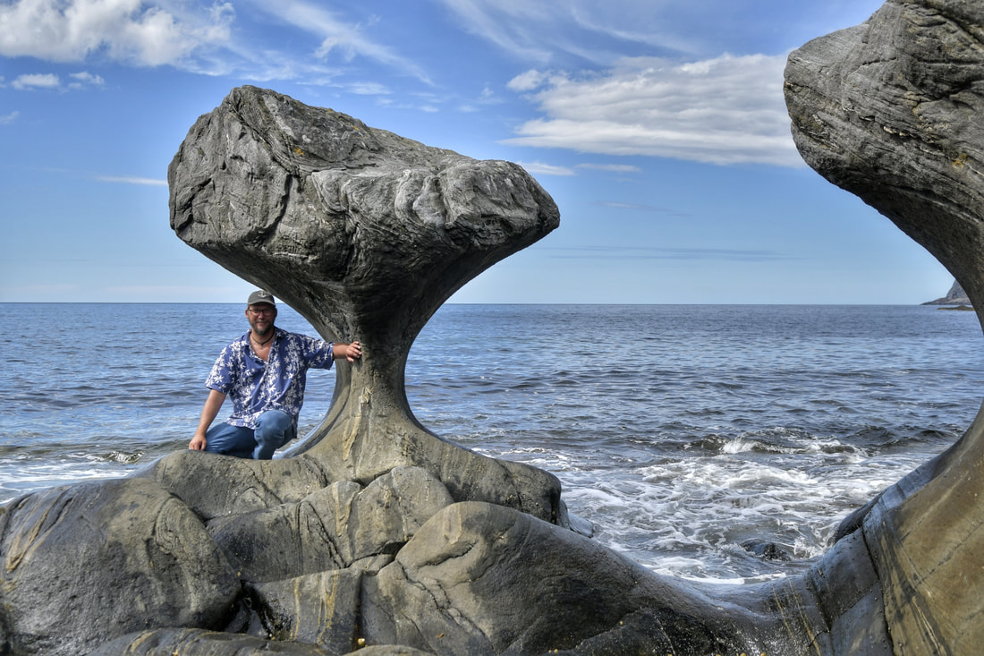
Not far from Måløy is Kannesteinen, a very special rock formation. Throughout thousands of years, ocean waves has grinded against the rock from both sides, shaping it into an hour glass form.
On days with low tide and calm seas, you can walk out to it. Beware that the road from Måløy to Kannesteinen is very narrow, so you'll probably have to give way to cars going in the opposite direction several times. Drive carefully!
On days with low tide and calm seas, you can walk out to it. Beware that the road from Måløy to Kannesteinen is very narrow, so you'll probably have to give way to cars going in the opposite direction several times. Drive carefully!

From there on, you can drive to Selje - a quiet little village by the sea. It has a small beach, perfect for relaxing and taking a bath on sunny days.
There are also some restaurants. We recommend having lunch at Frimannsbuda, where you can enjoy a beer and a pizza on the sea front before moving on.
There are also some restaurants. We recommend having lunch at Frimannsbuda, where you can enjoy a beer and a pizza on the sea front before moving on.
Continuing the road trip, set your destination on Hoddevik. This small village is world famous for its sandy beach and wave surfing! When the weather comes from north-west, waves will break on the beach, attracting many surfers to the place.
Beware that the roads leading to this place are very narrow and winding, so be prepared to give way for meeting traffic.
Beware that the roads leading to this place are very narrow and winding, so be prepared to give way for meeting traffic.


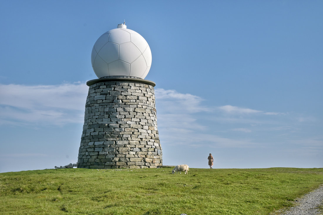
Next up, enter Vestkapp on your GPS. This mountain top gives a spectacular view of Stadhavet and the surrounding area. It is also the location of one of Norway's big weather radars, providing important information about the incoming weather along the coast.
Vestkapp is Norway's westernmost mountain platou.
(It is however not mainland Norway's westernmost point. That point is located at Vardetangen in Austrheim, much further south.)
Vestkapp is Norway's westernmost mountain platou.
(It is however not mainland Norway's westernmost point. That point is located at Vardetangen in Austrheim, much further south.)


If you have time to spare, you can visit Eltevik batteri, the remains of a nazi fortification from WWII. This was one of many coastal fortresses built to prevent allied ships from passing and entering the nearby fjords.
After this, it's time to head back to Steinsvik. You can drive towards the village of Åheim and then continue to Lauvstad. This brings you back to Dalsfjord, and you have now taken a full round-trip without using any ferries.
After this, it's time to head back to Steinsvik. You can drive towards the village of Åheim and then continue to Lauvstad. This brings you back to Dalsfjord, and you have now taken a full round-trip without using any ferries.

A full day round-trip to the west of Dalsfjord.
EAST
➤ A giant toad and spectacular mountains!
Driving eastwards from Dalsfjord, you'll see some of the nicest fjord scenery in all of Norway.
Our recommended route: Head towards Folkestad and take a right by the ferry. First: set your GPS to Paddeland, and you'll drive through parts of Austefjord, which is Dalsfjord's neighbouring fjord.
Driving eastwards from Dalsfjord, you'll see some of the nicest fjord scenery in all of Norway.
Our recommended route: Head towards Folkestad and take a right by the ferry. First: set your GPS to Paddeland, and you'll drive through parts of Austefjord, which is Dalsfjord's neighbouring fjord.
One of the first stops on this round-trip is a giant concrete toad, a sculpture built as a homage to northern Europe's largest colonies of toads!
Every spring, thousands of toads cross the road to reproduce. When building a new road through the area, they had to build many small tunnels for the toads to safely cross under the trafficked road. And then they made a giant toad as a homage to the toads colony.
Every spring, thousands of toads cross the road to reproduce. When building a new road through the area, they had to build many small tunnels for the toads to safely cross under the trafficked road. And then they made a giant toad as a homage to the toads colony.

After kissing the toad, you can continue on E39. If you have plenty of time, you can make a stop at Bjørke, a small but interesting village. Here you can visit Bakketunet, which is open every Sunday in the summer. This is a beautifully preserved and restored farm from the 16th century. Sometimes it has art exhibitions.
Next, head towards Grodås in Hornindal (you'll pass through the long Kvivstunnelen on the way), but take a left on Fv60 right before entering Grodås.
Next, head towards Grodås in Hornindal (you'll pass through the long Kvivstunnelen on the way), but take a left on Fv60 right before entering Grodås.
From here, you can set your GPS towards Lygnstøylvatnet.
On the way there, you'll pass through Norangsdalen, which is a very scenic valley with steep mountains on both sides of the road.
Next to the fresh water lake Lygnstøylvatnet there used to be several summer farm houses until 1908, when a rock slide fell from the nearby mountain Keipen. The rocks formed a dam at the end of the water, which caused the water to rise, flooding the roads and houses. On calm days, you can still see the foundations of the houses under the surface.


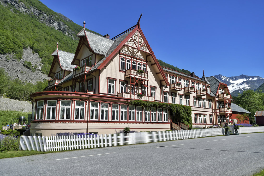
A few minutes down the road, you'll arrive at Hotel Union Øye. This hotel, built in the late 19th century, has been the destination for European aristocrats and explorers for generations.
It has been restored to it's former glory and more, making it one of the nicest historic hotels in Norway. All the rooms have different themes, and you can look into the rooms which are not occupied by guests.
The hotel has a rich history and even a ghost! There's a restaurant for enjoying a local snack or a cup of tea in the outside garden.
Continuing down the road, you'll pass the small village of Urke, which has a small grocery store, a camping site, a plant nursery, a marina and a pub/cafe (Urke Kaihus) in the old dock house down by the sea.
It's worth stopping for a beer or a soft drink and enjoy a spectacular view of the mountain Stålberghornet (1285 meters) on the opposite side of the fjord.
It's worth stopping for a beer or a soft drink and enjoy a spectacular view of the mountain Stålberghornet (1285 meters) on the opposite side of the fjord.


After this, you can take the ferry from Leknes to Sæbø. If the weather in nice, you can continue on the ferry from Sæbø to Trandal, which has one of the most unique pubs/restaurants in Western Norway (Christian Gaard).
In a village with only a handful of inhabitants and no roads leading in or out, you'd think building a pub was a terrible business idea. But the pub has survived and is now a success that attracts thousands of visitors every year.
It's also the location for several music festivals, like Trandal Blues, Trandal Rock and Trandal Country! Getting to and from Trandal by ferry is a bit unpractical, but in addition to ferry, there's also a private charter boat available on request.


Sæbø is village which has gained a lot of popularity, both in the winter and the summer. It's a popular basecamp for mountain hiking and skiing. Here are several small shops, a small beach, a hotel and a floating sauna.
After visiting Sæbø, it's time to head back. On the way you will pass through Ørsta and then onwards to Volda, where you can take the ferry over to Folkestad and Dalsfjord.
After visiting Sæbø, it's time to head back. On the way you will pass through Ørsta and then onwards to Volda, where you can take the ferry over to Folkestad and Dalsfjord.

NORTH
➤ City life, shopping and a gigantic aquarium!
Heading north, you can visit the capital of the region Sunnmøre: Ålesund. With a population of about 59.000, you'll find many urban attractions.
The city centre is surrounded by Brosundet, a narrow seaway dividing the city in two. The city burned to the ground in 1904 and the houses was rebuilt in the special "Jugend style".
To get a good overview of the city centre, you can drive (or walk) up to Fjellstua, which gives a panoramic view of the city and it's surrounding islands.
At the western end of the city peninsula, one of Europe's best and largest salt water aquariums, Atlanterhavsparken, is built.
The giant Atlantic tank holds 4 million liters of sea water and is home to a variety of fish and sea creatures. When it's feeding time, the visitors can watch through the large window as a diver feeds the cod and other fish types who live in the tank.
The giant Atlantic tank holds 4 million liters of sea water and is home to a variety of fish and sea creatures. When it's feeding time, the visitors can watch through the large window as a diver feeds the cod and other fish types who live in the tank.

Photo: Atlanterhavsparken.no
Another nice attraction this day, is to drive out to one of the islands surrounding Ålesund. In perticular is Alnes fyr a scenic spot. You can walk to the top of the lighthouse there and gaze out over the beach and the surrounding islands.


On the way back, you can stop at Moa to do some shopping at Norway's 3rd largest shopping center. Here you'll find about 200 different shops, selling everything from local products to McDonald's hamburgers.

SOUTH EAST
➤ Glaciers, waterfalls and an easy trip to the top of the mountain!
To the south west of Dalsfjord, you can find some amazing attractions. Start off by driving towards Nordfjordeid. There are two options for driving east on this route. We recommend taking the full circle so you'll experience both roads.
A few minutes before arriving in Nordfjordeid, take a left towards Stryn. On the way there, you'll drive along Hornindalsvatnet, which is the deepest fresh water lake in Europe (514 meters deep).
Stryn is a small village similar to Volda and Ørsta, worth a short stop to get dinner or do some shopping before heading to Loen.
One of the first thing you'll see when arriving in Loen, is the Skylift - one of the steepest cable carts in the world. It will take you from sea level to the top of the mountain Hoven (1.011 meters above sea level) in a matter of minutes.
From there you can enjoy the spectacular view of the surrounding area and Lovatnet. There's also a restaurant serving food and drinks on top of the mountain.
From there you can enjoy the spectacular view of the surrounding area and Lovatnet. There's also a restaurant serving food and drinks on top of the mountain.


Back down again, you can continue along the picturesque, turquoise-colored Lovatnet towards Kjenndalsbreen, an arm of the larger glacier Jostedalsbreen - the largest glacier in continental Europe
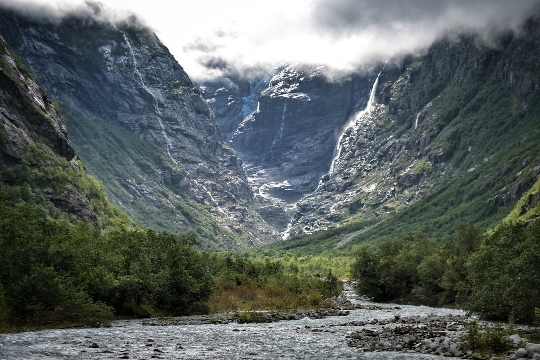
View of Kjenndalsbreen.
After visiting Kjenndalsbreen, it's time to head back. You can set the course towards Nordfjordeid and then north to Folkestad and Dalsfjord.
A great place to relax and perhaps have a picnic on the way, is by Sagedammen - an old sawmill by a quiet pond. This area is open to the public, and has several paths for walking in the nearby area.
A great place to relax and perhaps have a picnic on the way, is by Sagedammen - an old sawmill by a quiet pond. This area is open to the public, and has several paths for walking in the nearby area.


Another must-see attraction just up the road is Tvinnefossen - a waterfall you can walk behind!
You'll have to walk 1,5 km by foot from the parking place to see the waterfall. It is biggest in the spring when the snow melts in the mountains, or when it has been raining a lot.
You'll have to walk 1,5 km by foot from the parking place to see the waterfall. It is biggest in the spring when the snow melts in the mountains, or when it has been raining a lot.
On the way back, you can stop by Nordfjordeid to do some shopping and sightseeing. If you haven't been there before, you can visit the Sagastad viking ship museum before continuing north again to Dalsfjord and Steinsvik.

STEINSVIK.COM
Steinsvik Fjordhytter © 1994-2025
Mehr als 30 Jahre Erfahrung mit der Vermietung von Ferienhäusern in Dalsfjord
Org.nr. 917 871 388 MVA
Mehr als 30 Jahre Erfahrung mit der Vermietung von Ferienhäusern in Dalsfjord
Org.nr. 917 871 388 MVA

